Maupiti was probably the most "must see" island on my itinerary.
Very few tourists, no one speaks English, authentic, laid-back atmosphere, you can walk everywhere, beautiful lagoon, Bora Bora 50 years ago, beautiful Tereia beach, not much information online... No hotels, no Booking, Airbnb, Expedia... I searched for accommodation options on Google maps, Facebook, etc. According to the information available on the internet, you have to book flights and accommodation at least six months in advance.
I worked with this information and this is roughly what resonated in my mind when I was planning the whole thing.
The number of flights to this island is not large, so it is best to plan it as first or last - this is because the frequency of flights to/from Tahiti is the highest - and if you opt for the Air Tahiti pass, then you have to start and finish on Tahiti.
Alternatively, you can fly to/from Maupiti via Raiatea or Bora Bora. These two islands serve as a sort of transfer hubs for Air Tahiti (in addition to the island of Tahiti itself).
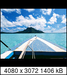
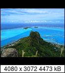
The morning flew by and I'm back on the boat and heading back to the main island. A view of Maupiti Island, including Mont Teurafaatiu, from a rather unusual angle.
If there was something in high numbers on the islands, it was definitely the dogs. I don't think I've seen a cat before, hence the photo (-:
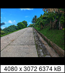
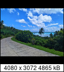
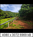
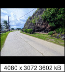
The view from the only part of the road around the island that goes uphill (and then downhill), otherwise it is more or less flat. I was impressed by how clean and well maintained the public areas on the island were. I think it is also due to the fact that there are a relatively large number of people employed by the local government - including employees responsible for maintenance and cleaning of public areas, etc. Which kind of makes sense to me, because unless someone works in tourism, either directly or indirectly, there's not much else work to do in the private sector.
 All EXIF information is retained in the uploaded photos, incl. GPS coordinates, so it is possible to see exactly where the particular photo was taken.
The electricity supply for the island is provided by a small diesel power plant near the port.
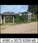
A phone booth, you don't see that often here anymore, that's why I took a picture.
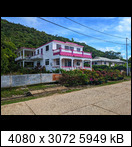
The local architecture is very traditional, typical of localities in this climate zone. Similar to the Seychelles, for example. But this house stood out.
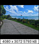
The road around Maupiti is approx. 13km long. Plus some paved narrow turn-offs from the main road to some higher building, small plantation, etc.
For how small an island it is, there were quite a few cars driving around. Not that the traffic was any kind of heavy or annoying, not really. But I was expecting it to be a bit more quiet in that respect. Just a sidenote. It certainly wasn't a shock like La Digue, where I was expecting 3 cars and...


What kept bugging me, especially on small islands... I mean, there really are all sorts of cars here... French, Japanese, Chinese brands that I first saw here... Old American pickups, new Mercedes and BMWs, a Volkswagen here and there... In terms of age, from 50-year-old cars to the modern ones. I've even seen a Hummer here in Maupiti:
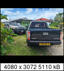
One thing I don't understand: how do they handle car repairs on Maupiti, for example? I mean in particular the availability of spare parts, special service fixtures, diagnostics, know how.... Especially if there is one - two garages with basic equipment on the island?
One of the churches on the island, this particular one was located in Vai'ea, which is kind of the "main" village on the island. I couldn't find out what church it belonged to.

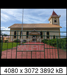 Generally, in terms of outreach, Seventh-day Adventists were quite visible on the islands. If only because they had a sign in front of every church with their logo.
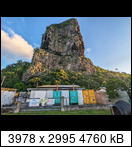
The initial part of the hike to Mont Teurafaatiu, which is the highest peak on the island, elevation approximately just under 400m.
The start was a bit confusing as the telecommunications antenna serves as a starting point. The problem is that in the meantime another antenna has been built in this location, which has a nice path leading to it and is also more visible.
 Additionally, I was working with info from the previous day that the path is hard to see - so I didn't find it strange that I couldn't see any path near the antenna. So I searched, and searched, until I reached the second antenna and saw a nice path leading up.
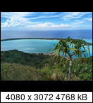
View of Vai'ea village from approximately the first third of the hill.
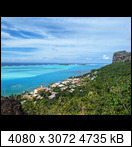
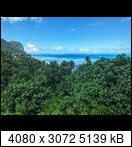
And here is the view from the top of the hill. It was a beautiful view and I spent almost an hour there. The weather was great and all the colors were just amazing. Definitely, one of the highlights. Onoiaou pass in the background, Motu Tiapaa on the left, Motu Pitiahe on the right.
 Otherwise, this hike is one of those that look easy from the description on the internet, but are actually a bit more challenging. The climb was quite steep though and sometimes I preferred to go on all fours. Approximately the last third of the climb was secured with ropes. At the top I was out of breath for a few minutes.
I chose a different route for the descent, interestingly it is not shown on openstreetmaps at all. However, it is marked and clearly visible. I would also say that this route is less physically demanding and dangerous.
View from the descent.
The start of this trail is in the village of Pauma, just before the Palais de la Mer if you are coming from Vai'ea. Here’s the photo of the trailhead.


